
What We Do

From job sites to your driveway — aerial inspections for every property owner

Four ways we help property owners see what's really going on — from roof and pavement inspections to facade condition surveys and LiDAR site mapping.

Thermal Roof Inspections

Infrared imaging pinpoints trapped moisture, failed insulation, and heat loss before a small leak becomes a full re-roof. We fly after sunset, once the day's solar heat has cleared the surface, so the thermal data reflects what's actually happening underneath the roof — not just residual sun warmth. Flown on our Autel EVO II Dual 640T V3, we cover the full roof plane and match every thermal frame with a visual RGB frame, so anomalies aren't just a temperature reading — they're a location you can point to.
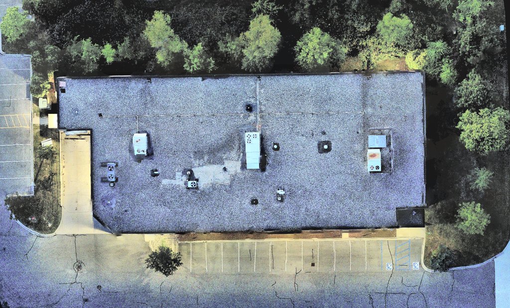
RGB aerial photo of a commercial flat roof, appearing normal to the eye
RGB — what the eye sees
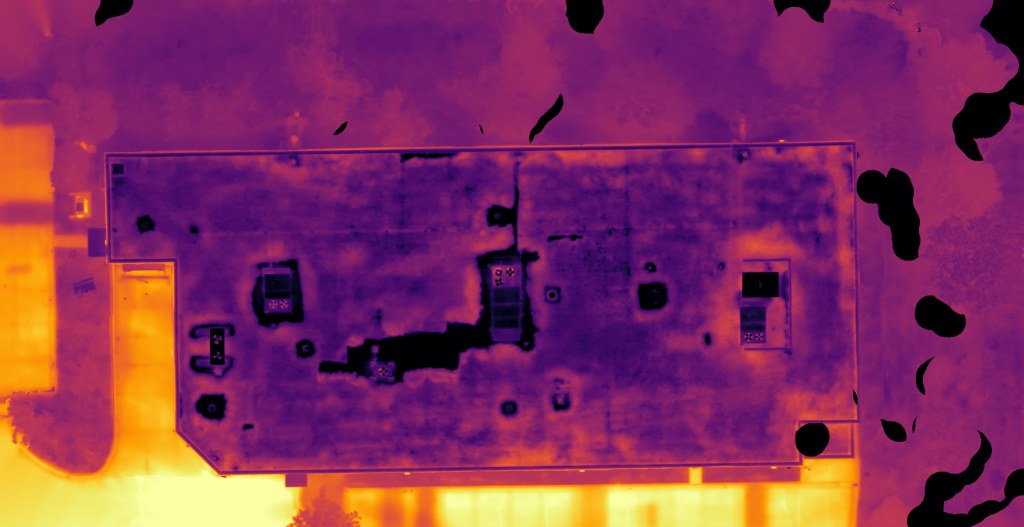
Thermal scan of the same roof revealing a large area invisible in the RGB photo
Thermal — what we find

An actual Detroit Drones roof inspection — the cooler area in the thermal scan isn't visible in the RGB photo at all.

What We Capture

  • Radiometric thermal imagery across the roof plane
  • Matched RGB imagery for visual context
  • GPS-referenced anomaly locations

What You Get

  • Annotated report with flagged anomalies
  • Roof plan overlay showing problem areas
  • Raw imagery available on request

Ideal For

  • Seasonal maintenance checks
  • Scoping repair vs. replacement
  • Insurance & warranty documentation

Pavement Thermal Scanning

Thermal survey of parking lots and drive lanes, flown on our Autel EVO II Dual 640T V3 after sunset — once the pavement has shed the day's solar heat — to flag subsurface deterioration, base failures, and drainage issues while they're still cheap to fix. Temperature differences in asphalt and concrete often show developing problems well before they're visible on the surface.

What We Capture

  • Thermal differential mapping of the surface
  • RGB context imagery of the lot or drive lanes
  • GPS-tagged distress areas

What You Get

  • Annotated report highlighting distress zones
  • Data organized for maintenance planning

Ideal For

  • Facility & property managers
  • Municipalities
  • Owners planning resurfacing or reserves
Coming Soon

Facade Scanning

Close-standoff aerial survey of building envelopes and cladding — flown on our Autel EVO II Dual 640T V3, combining thermal and RGB imagery to document conditions and deferred maintenance — without the cost or schedule hit of renting a lift or scaffolding.

What It Will Capture

  • Radiometric thermal imagery of the facade
  • High-resolution RGB imagery for visual context
  • Close-standoff, tier-by-tier coverage

What You'll Get

  • Annotated thermal & visual condition report
  • Organized by elevation and tier

Ideal For

  • Building envelope inspections
  • Cladding & facade condition reviews
Coming Soon

LiDAR Mapping & Surveying

High-density point-cloud capture for site mapping, volumetrics, and as-built documentation, flown on our DJI Matrice 400 with the Zenmuse L3 payload.

What It Will Capture

  • High-density LiDAR point-cloud data
  • Site-wide coverage in a single flight

What You'll Get

  • Point-cloud exports in standard formats
  • Volumetric & as-built documentation

Ideal For

  • Construction & engineering projects
  • Agriculture & forestry surveys
  • Site mapping & earthwork volumetrics
Coming Soon

Photogrammetry & 3D Mapping

Hundreds of overlapping aerial photos, stitched into a single orthomosaic map and 3D model — the same processing behind every orthomosaic in our thermal reports, flown here as its own standalone deliverable on our DJI Mavic 4 Pro.

What It Will Capture

  • Dense, overlapping high-resolution RGB imagery
  • Full-site coverage in a single flight

What You'll Get

  • Orthomosaic map of the site
  • 3D model / point cloud

Ideal For

  • Site mapping & progress documentation
  • Real estate & marketing visuals
  • Construction & engineering projects

How It Works

From first call to finished report

01

Tell us about the site

Property type, size, and what you need to see. Most quotes go out same day.

02

We plan the flight

Airspace check, standoff distances, and timing worked out before we ever show up.

03

We fly & capture data

Thermal, RGB, or LiDAR capture depending on scope — on site, no lift or scaffolding required.

04

You get a report

Annotated findings delivered digitally — often in minutes to hours after the flight, depending on the size of the job.

Not sure which service you need?

Tell us about the property and what you're trying to figure out — we'll point you at the right service.